Beyond the map: a WebGIS system based on ArcGIS Enterprise to showcase social projects
In the third sector, numbers alone are not enough. Tools are needed that can show connections, describe relationships, and make social impact visible. When dozens of organizations work together on complex projects spread across the country, having a clear and up-to-date overview is not just useful: it is essential. This is where ArcGIS Enterprise comes in, as an enabling platform for managing and visualizing geographic data.
In 2024, Con i bambini , in synergy with Fondazione con Il Sud, launched a process to improve access to data related to its network of projects and partner organizations. The goal was not simply to “show a map,” but to build a dynamic, accessible, and living platform capable of reflecting the real-time status of activities.
The solution took shape through the development of a WebGIS: an online geographic information system designed specifically for the needs of a non-profit organization.
The requirement: simplicity, transparency, connection
The data collected and managed by the Foundation are extensive: names of organizations, involved territories, funded projects, types of intervention, registry information, and much more. But data, if isolated, tell no story.
The challenge was to transform this information into a useful and accessible experience. The main needs were:
- A system that simplified the reading of complex information
- A method to update data automatically, without manual operations
- A platform usable even by those without advanced technical skills
- A tool capable of visually telling the connections between organizations and projects
In other words, a digital space was needed where social change could be navigated with ease.
The process: transforming data into experience
The project was structured into four main phases, all aimed at building a solid and flexible tool.
- Solid Infrastructure: ArcGIS Enterprise
The first phase focused on configuring ArcGIS Enterprise, the reference platform for hosting geographic data and the WebGIS application. This environment guarantees security, stability, and scalability.
- Direct Connection to the Original Data
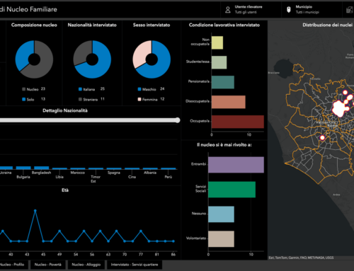
To avoid duplication and make the data “live,” a direct connection was established with the Foundation’s PostgreSQL database via ArcGIS Pro. In this way, data “views” were transformed into Query Layers, meaning information layers that update automatically based on the original source.
This approach ensures that the information displayed on the map is always current and aligned with real data.
- Designing the WebGIS Experience
Using ArcGIS Experience Builder, a customized and intuitive interface was created, enriched with:
- Custom widgets for filtering and navigating organizations and projects
- An interactive map showing all involved organizations in real time
- Informative pop-ups that allow users to explore relationships and project details in depth
The user experience was designed to be smooth and accessible to everyone, without requiring specialized skills.
- Training for Autonomy
Finally, Foundation staff received hands-on training on how to use the platform and independently create new content (maps, applications, layers) through ArcGIS Pro and ArcGIS Online.
The result is a system that is not static but can evolve over time alongside the organization.


A voice from the social enterprise Con i bambini
During and after development, the Foundation team recognized the strategic value of the WebGIS system in strengthening its social mission. An official statement reads:
“We are very satisfied with the result achieved. The developed map represents for us not only a technological tool, but a true space of knowledge: a dynamic and accessible environment that visually returns the work of our social enterprise and that of many Italian Third Sector Organizations (ETS) engaged every day in combating school dropout and situations of marginalization and inequality.
Thanks to a tailor-made approach, the system fully meets our needs for synthesis, continuous updating, and ease of use, allowing us to effectively enhance the social impact of the supported projects.
We particularly appreciate the ability of the WebGIS to clearly highlight the connections between organizations, territories, and interventions, helping us to read and communicate the complexity of our work with clarity.
A sincere thank you to those who worked with competence and care to create this tool: a concrete step toward increasingly transparent, shared, and change-oriented data management.”
A project that highlights social value
This WebGIS is not just a technical tool. It is a form of visual storytelling. A way to:
- Make social impact visible
- Foster connections between local organizations
- Improve internal communication and activity monitoring
- Use geography as a shared language
In a single platform, data, stories, territories, and people come together. Because sometimes, seeing how everything connects is the first step toward truly building a network.
Who we worked with

Con i Bambini is a non-profit social enterprise founded in 2016 to implement the Fund to Combat Child Educational Poverty. It operates throughout Italy, supporting projects that improve educational opportunities for children and young people, involving schools, families, institutions, and third sector organizations. In addition to funding initiatives, it promotes research and monitoring—including through the #ConiBambini Observatory with Openpolis—to better understand the conditions of minors and promote more effective educational policies.