Every year Save the Children Italia dedicates an Atlas of Childhood at Risk to the condition of minors in our country, using data collected from authoritative sources and with a particular focus on some issues chosen from year to year.
Through a careful investigation based on data and on the visual effectiveness offered by maps and graphs, the Atlas presents the situation of childhood in Italy, highlighting the areas and sectors where there is a strong need for action and improvement.
Watch the interview to find out how the project started
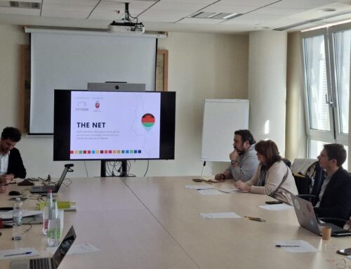
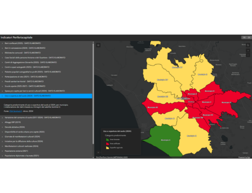
gisAction has been supporting Save the Children in this project since the 2011 edition of the Atlas and the main tool it uses is the GIS (Geographical Information System), an information system that allows the overlap of any information that has a geographical connotation, in order to be able to carry out effective analyzes and representations in the form of cartograms, maps, graphics.
All the Editions

The 2022 Edition | How are you?
A look at inequalities and their effects on health by focusing the lens primarily on three age groups: the first thousand days, children aged 3 to 10, and adolescents or preadolescents aged 11 to 17.
“Childhood in Italy today is increasingly a victim of inequalities. Social, economic, educational, gender inequalities. But inequalities have an even deeper trace, one that is almost invisible and that creeps into the body of every child who is conceived and conditions their health, development and growth.”


Atlas of Childhood at Risk 2022: maps, cartograms and graphs made by gisAction

Cover of the Atlas of Childhood at Risk 2021 edition
The 2021 Edition | The future is here
The in-depth study carried out in 2021 could not fail to take into account the nearly two years of the pandemic that have weighed on our lives and that have had particularly negative repercussions on the youngest children, adolescents, and all students and schoolgirls who have experienced, among other things, long periods of remote education as a result of school closures.
The Atlas will bring out a summary of what has been the impact of COVID-19 on the lives of children and adolescents, but more importantly what are the most urgent challenges we need to address to prepare ourselves for a future that leaves no more room for inequality.


Atlas of Childhood at Risk 2021: maps, cartograms and graphs made by gisAction

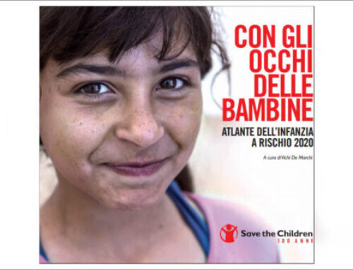
The 2020 Edition | Throughout the eyes of the little girls
“Throughout the eyes of the little girls” is the edition that shows a photograph made of child poverty and educational inequalities, from north to south and proposes a focus on the condition of baby girls and girls in Italy, highlighting a post-pandemic future at risk for them.
The infographics, maps and illustrations created by gisAction play a fundamental role in accompanying the testimonies and data of the Atlas.


Atlas of Childhood at Risk 2020: maps, cartograms and graphs made by gisAction

The 2019 Edition | Children’s time
The 2019 edition represents the Tenth edition and proposes a balance on the condition of minors in Italy, from 2008 to 2018. Ten years have passed since the first edition and this year the Atlas wanted to try to create a collection of the most valuable elements: the new time, youth mobilization on various issues, time lost, what has been missed in policies to improve the living conditions of children in our country, and the time found, the initiatives, the works of the associations and research.
Using GIS tools, various comparative analyzes have been carried out on the data which return a new and complete view of the phenomena under consideration.


Atlas of Childhood at Risk 2019: maps, cartograms and graphs made by gisAction

The 2018 Edition | The suburbs of children
In 2018, the underlying theme of the Atlas is that of spaces and suburbs, considered the new “cities of children”. In these urban areas, which are more stepmothers than mothers, there is often a lack of safe spaces for play, culture, sport and meetings, services that are light years away from social and educational needs, blind to the very existence of children. This distance produces disastrous effects, because the poverty of spaces does more damage to the children than the same economic poverty.
With dozens of maps, the Atlas presents data on the condition of childhood, child poverty and “educational poverty”.


Atlas of Childhood at Risk 2018: maps, cartograms and graphs made by gisAction

The 2017 Edition | Letter to the School
The 8th Atlas of Childhood (at risk) intends to offer documents, data and tools for understanding the situation of the school in Italy. The purpose is to indicate the still strong value of the lessons of the great masters of the past, the validity of some innovative experiments and the importance of the entire educating community, but without hiding the problems that still exist or the presence of gaps in the school system and in training.
The Atlas, published by Treccani, shows, with an abundance of data, how little has been done over the decades to put the school in a position to function well, in the belief that only such a rich overview can help to better understand which paths to continue along, and which ones to renew, which improvements are necessary and how many changes still need to be made to have a better school, and therefore a future.


Atlas of Childhood at Risk 2017: maps, cartograms and graphs made by gisAction

The 2016 Edition | Kids and Superheroes
The children ‘at risk ‘are the protagonists of the 7th Atlas. This edition brings to light the harsh reality but, at the same time, it enhances the resources and resilience capacities of minors, real “Superpowers” to resist in situations of precariousness and overcoming difficult living conditions.
Maps, infographics and various indicators document that there are many children and young people at risk, for whom the principles of the UN Convention on the rights of the child often remain only a mirage.


Atlas of Childhood at Risk 2016: maps, cartograms and graphs made by gisAction

The 2015 Edition | Children without
The sixth edition of the Atlas documents the most serious deprivations affecting children in Italy, bringing to light the devastating impact of illegality on their lives.
With the help of data and maps, the research shows the devastating impact of these phenomena and the very high price – human, economic, political, cultural – paid by childhood to the proliferation of illegality in many fields and in many forms.


Atlas of Childhood at Risk 2015: maps, cartograms and graphs made by gisAction

The 2014 Edition | The horizons of the possible
The 5th Atlas of Childhood crosses cities, streets, neighborhoods, rooms and other places of childhood and adolescence, with the help of new data and maps, and a robust photographic kit.
The data document less and less spaces and opportunities for children, squeezed between poverty, life in metropolitan areas often without services, a school “halved”.


Atlas of Childhood at Risk 2014: maps, cartograms and graphs made by gisAction

The 2013 Edition | Italy Upside Down
Between unemployment, drop in consumption, housing emergency, municipalities in default, welfare cuts, low birth rate … Italy seems to have turned upside down. After having explored the past (2011, In search of Young Italy) and the future (2012, Maps to reconnect to the future), Save the Children’s Atlas of Childhood (at risk) dives into the present to focus on the effects of the crisis on children’s lives and focus on risk factors.
To recognize, at the end of the journey, that poverty and inequalities are not a contingent fact but have their roots in the crisis of skills. To straighten Italy we need to start from here, rekindling knowledge and educational paths, inside and outside the school.
In addition to showing the effects of the crisis on minors, the new Save the Children Atlas seeks to explore its causes with the help of scientific literature and maps created by gisAction.


Atlas of Childhood at Risk 2013: maps, cartograms and graphs made by gisAction

The 2012 Edition | Maps to (re) connect to the #FUTURE
The Atlas projects us into the future, indicating the decline on which we risk slipping in the coming decades and the risks that the denial of the rights, even the most basic ones, of children and adolescents entails.
The cartographic program offered by this edition of the Atlas of Childhood (at risk) shows without the possibility of denial how our idea of the future and the world we are helping to build are eroding the idea and the very possibility of the future of new generations.


Atlas of Childhood at Risk 2012: maps, cartograms and graphs made by gisAction

The 2011 Edition | In search of the young Italy
On the occasion of the 150th anniversary of the unification of Italy, the Atlas proposes an in-depth study on Garibaldi’s boys, a contribution which, however, is not just a tribute but also an unusual instrument of investigation. In fact, following those teenagers who somehow dreamed of the homeland we live in also allows us to compare the “young Italy” of the time with the current one.
The study makes available to the public a large collection of maps created by the gisAction team, on the situation of childhood and adolescence in Italy.
The data collection and mapping work focused in particular on specific indicators of the world of childhood and adolescence. By applying to Italian minors what is generally used to represent and analyze physical, geological and environmental data, it was possible to create more than 70 maps, from demographics to the environment, from the internet to social spending, from nurseries to schools, from poverty economic to juvenile justice, and so on. A cartographic program of minor Italies of different colors, very often iridescent within them to signal the disunity of a country (in particular the distances between North and South, but also between region and region, between province and province) gathered 150 years ago also thanks to the sacrifice of so many boys.