GIS for Data Value Chain enables organizations to leverage geospatial data in internal and external decision-making processes. It also supports more accurate and effective data collection. In this way, information becomes a strategic resource for planning and operational management.
Firstly, GIS promotes robust data management. As a result, the integrity, accessibility, and proper organization of information are guaranteed. In addition, databases are more structured, up-to-date, and easily searchable in different application contexts.
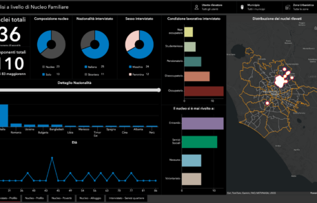
Secondly, thanks to the use of advanced GIS tools, complex data is transformed into intuitive maps and visual formats. This makes the information clearer to read, even for non-technical users. Furthermore, visualization facilitates the comparison of scenarios and the identification of key issues.
At the same time, GIS-based data analysis allows patterns, trends, and spatial relationships to be identified. For this reason, decisions can be based on objective evidence. At the same time, the ability to predict and assess impacts is increased.
Furthermore, GIS-based storytelling enriches communication. As a result, data becomes more understandable and engaging for stakeholders, partners, and citizens. At the same time, results can be communicated in a clear, transparent, and verifiable manner.
Finally, integrating GIS into the Data Value Chain allows the collection, analysis, visualization, and dissemination of information to be linked in a single, coherent flow. In summary, GIS for the Data Value Chain improves organizational efficiency, strengthens decision-making, and stimulates operational innovation. It also promotes cooperation between offices, common standards, system interoperability, and the conscious use of data as a strategic asset for the continuous development of organizations.